What has been received?
Review available aircraft-reported identity, position, height, and speed from Remote ID broadcasts. Keep RF and control-link observations visible as a separate source of context.
A CLEARER PICTURE. A BETTER RESPONSE.
Created by a law enforcement officer. Built for public safety.
Know more about the airspace around you. RIDwatch brings Remote ID, radio-frequency observations, and field intelligence into one practical operating picture.
CREATED BY A LAW ENFORCEMENT OFFICER. BUILT FOR PUBLIC SAFETY.
There had to be a practical way to give the agency better drone awareness.
After supporting two successive Independence Day celebrations from the air, RIDwatch’s founder saw a gap: local teams needed a clearer picture of nearby drone activity, but the systems he explored were beyond the agency’s budget.
RIDwatch grew from that experience—combining law enforcement, aviation, and cybersecurity with AI-assisted development and commercial off-the-shelf hardware.
An observation is the starting point. Situational awareness comes from understanding it in context.
Turn received aircraft information and RF observations into context your team can use.
At a crowded public event, a campus, or an airfield, your team needs to understand what has been observed, where a reported aircraft is, and how its activity relates to the site you are protecting. RIDwatch brings available Remote ID, RF observations, receiver health, and retained history into one view.
That need came from real public-safety operations: while our own drone supported overwatch, searches, and rescues, the team also needed awareness of other aircraft nearby. RIDwatch helps put received information in front of the people making the next call.
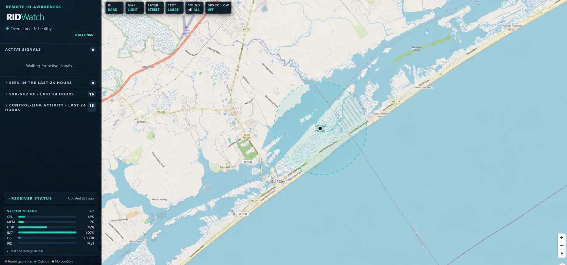
Review available aircraft-reported identity, position, height, and speed from Remote ID broadcasts. Keep RF and control-link observations visible as a separate source of context.
Compare valid reported aircraft positions with your configured boundary. Receiver location identifies where an observation was collected; it does not locate an unknown transmitter.
Use timestamps, signal history, classification reasons, and retained encounters to review developing activity. Receiver health helps you understand whether the equipment is listening as expected.
Use the operating picture to brief personnel, support established response procedures, and preserve context for later review. An observation or handling label supports human assessment; it does not establish malicious intent.
Select a mission to explore where
RIDwatch can support your team.
Support incident command and event operations with broadcast aircraft information, a configured boundary, and retained observations for later review.
Discuss your mission +Receive-only awareness. Human judgment stays at the center of the response.
Illustrative values using RIDwatch data fields. RSSI changes alone do not establish aircraft identity or movement.
Mobile ready. Laptop ready. A password-protected Field Access Point connects your team to the local operating picture.
THE OPERATING PICTURE GOES WITH YOU
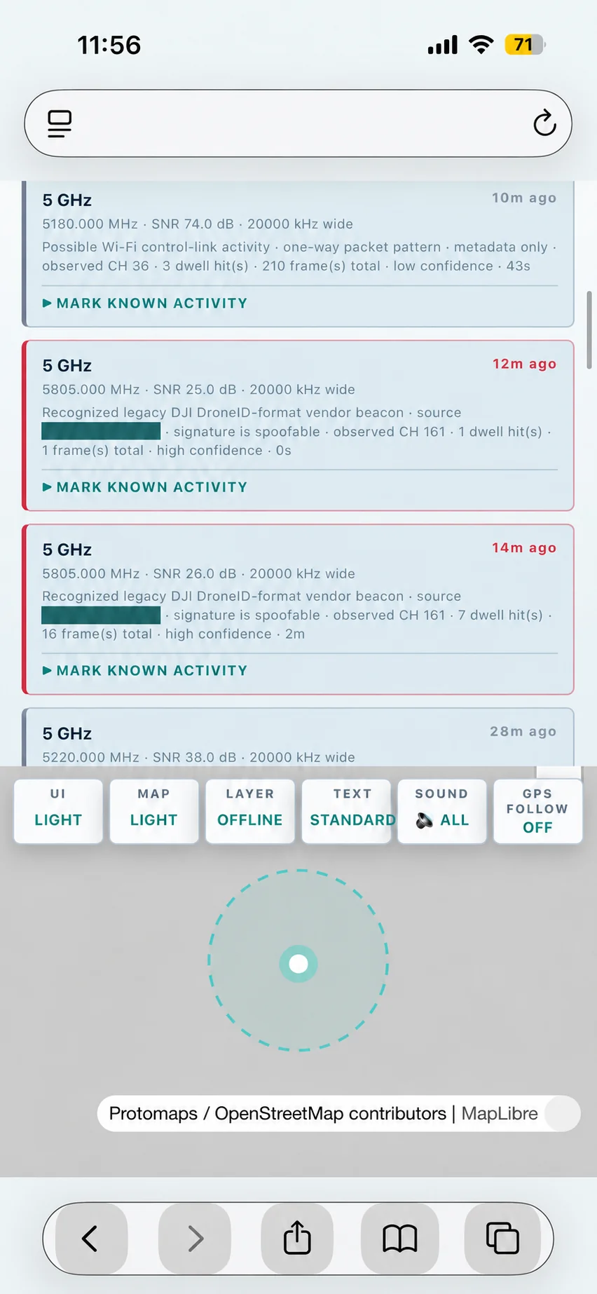
Review received observations from a phone or laptop through RIDwatch’s local dashboard. The onboard, password-protected Field Access Point provides a way to connect on site when an infrastructure network is unavailable.
This mobile view shows control-link observations, signal measurements, confidence, and the option to mark known activity. Your team can review the context where the work is happening, rather than returning to a separate workstation.
Local dashboard access can operate without an Internet connection. Offline maps must be prepared before deployment.
The airspace is changing.
Your operating picture should, too.
RIDwatch is a developing, field-deployable platform built around readily available hardware. It gives local teams a practical way to receive broadcast Remote ID, observe RF activity, and retain the context needed to make informed decisions.
For a scene, a campus, an investigation, or a municipal airfield—information that supports the people making the call.
Wi-Fi and Bluetooth reception brings available aircraft identity, position, and flight information into the dashboard.
Review RF and control-link observations with timestamps, signal history, and classification reasons. Unknown activity stays unknown.
Maps, geofences, history, receiver location, and HTML, PDF, and CSV reports support review after the moment has passed.
Operational health while you work.
A useful record when you review.
RUNTIME & SYSTEM HEALTH
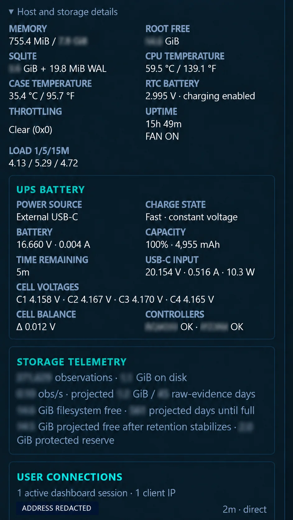
Monitor uptime, fan state, CPU and case temperatures, memory, storage, and supported battery telemetry from the same interface used for observations.
Storage telemetry shows retained observations, available capacity, and estimates based on current activity. Receiver and dashboard connection status help explain the health of the operating picture.
Actual telemetry screenshot. Network address redacted. Runtime and capacity values are a recorded snapshot, not battery-life or endurance guarantees.
HISTORICAL FLIGHT PLAYBACK
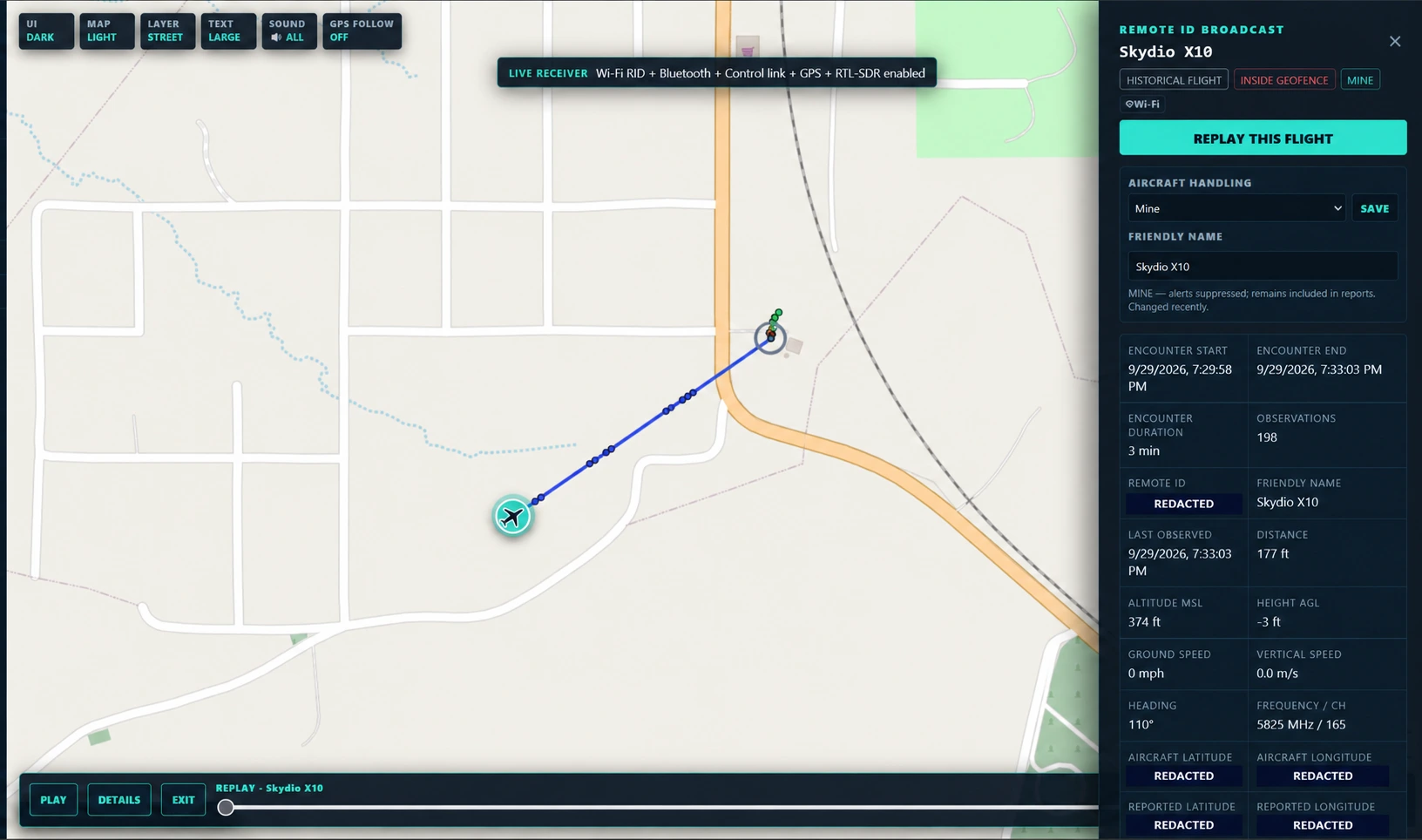
Replay retained flight observations on the map. Review the recorded track alongside encounter duration, observation count, reported flight values, and aircraft handling.
Use the playback timeline to revisit how an encounter unfolded and put the retained samples back into context.
Actual playback interface. Geographic labels, Remote ID, and aircraft and reported coordinates redacted for publication.
REPORTING & REVIEW
Export HTML, PDF, and CSV reports with aircraft encounters, geofence activity, control-link event details, and an RF summary organized by source, band, and confidence.
Receiver location is reported separately from aircraft position. RF activity remains distinct from confirmed aircraft broadcasts.
Open the public report sample +Counts from the uploaded report. RF event counts do not represent drone counts. The public sample omits identifiers, coordinates, and detailed encounter records.
Honest data needs to pass court scrutiny.
FROM OBSERVATION TO REVIEW
Integrity checks support review. They do not establish intent or guarantee admissibility.
Broadcast Remote ID can carry aircraft-reported identity and position. Generic Wi-Fi exchanges and sub-GHz activity are observations of RF—not proof that a drone is present. Recognized vendor formats remain distinguishable from verified identity.
Remote ID records retain a canonical raw-message SHA-256 fingerprint. History evidence bundles include chronological JSONL, a CSV convenience copy, aircraft profiles, and a manifest with hashes and record counts. A packaged verifier checks the exported bundle.
These checks help verify the integrity of retained and exported data. They do not authenticate an aircraft’s broadcast or its claimed identity.
Timestamped observations and audit records of operator disposition changes preserve context for review. Evidence exports support a documented custody process: record the operator, case or event, appliance, export time, selected time bounds, file hashes, and each transfer.
Preserve the original export and work from a verified copy. Agency procedures and documented handling complete the custody record; a hash alone is not a chain of custody.
Receiver coordinates show where RIDwatch observed an event. They do not locate an unknown transmitter. Remote ID aircraft coordinates, when available, are reported by the broadcasting device.
Reception varies with antennas, installation, terrain, interference, and the aircraft’s transmissions. Site evaluation and field validation should guide deployment. No universal detection radius is promised.
RIDwatch is a passive awareness platform. It does not jam, take control of, or stop aircraft. Observations support your established procedures and human review.
What RIDwatch does, who it serves,
and how to get involved.
During public-event operations in 2025 and 2026, our founder used a police drone for overwatch, searches, and rescue support. Even while that aircraft helped the team on the ground, activity from other drones remained a concern.
Federal counter-UAS assistance was not available for the 2026 event, and the commercial systems he explored were outside the agency’s budget. That experience led to a practical question: could readily available hardware give local teams useful drone awareness at a more accessible cost?
RIDwatch was created by John Ball, a law enforcement officer and cybersecurity professional with private-pilot and FAA Part 107 remote-pilot qualifications. His operational experience guides the project’s requirements.
The software is developed with AI-assisted coding and iterated through testing and field feedback. AI assists development; it does not replace an operator’s judgment or establish that an observed signal is a threat.
RIDwatch receives available Wi-Fi and Bluetooth Remote ID broadcasts and brings their reported information into a map-based operating picture. It also retains RF and control-link observations, receiver health, encounter history, and reports.
Where valid position information is available, operators can review aircraft tracks and relationships to a configured monitoring boundary.
RIDwatch can observe some RF activity without a Remote ID broadcast. Those observations may offer useful context, but a generic Wi-Fi exchange or sub-GHz signal does not by itself confirm a drone, identify its operator, or provide its location.
An aircraft that emits no receivable signal may be invisible to this platform. Reception depends on the equipment, installation, environment, and aircraft transmissions.
No. RIDwatch’s monitoring is passive. It does not jam, take control of, or stop aircraft. A geofence observation records a relationship to your configured boundary; it does not independently establish an unlawful flight.
The platform supports situational awareness, established response procedures, and human review. Handling labels such as “known rogue” are operator-assigned classifications, not proof of malicious intent.
The project began with public safety and also serves the awareness needs of private investigators, schools, and small municipal airports. A site evaluation can help determine where the platform is useful and where additional capabilities are needed.
For a demonstration, evaluation discussion, or purchase inquiry, contact [email protected].
YOUR MISSION. YOUR AIRSPACE.
Tell us about your site, your team,
and what you need to understand.